Archives
Enter a word or phrase to perform a general search across all records in the Archives catalog. You can also browse records in the catalog without performing a search.
Search Tips
- Searches are not case sensitive.
- Searching for multiple words connects them with OR by default. Matching records can contain any of the words.
- Connect multiple words with AND if you only want to see records containing both words.
- Use quotation marks to search for a phrase.
- Place an asterisk (*) at the end of a word as a wildcard.
222 results found. Records searched: 222
-
2014-008-0013 - Map
United States Department of the Interior Geological Survey Map of Squaw Pass quadrangle. 1967. Revised 1974. Green.
Record Type: Archive

-
2014-008-0014 - Map
United States Department of the Interior GeologicalSurvey Map of Central City quadrangle. 1972. Green.
Record Type: Archive
-
2014-008-0015 - Map
United States Department of the Interior Geological Survey Map of Nederland quadrangle. 1972. Green.
Record Type: Archive
-
2014-008-0016 - Map
United States Department of the Interior Geological Survey Map of Boulder quadrangle. 1966. Revosed 1979.. Green. City of Boulder-peach. Open space-white.
Record Type: Archive
-
2014-008-0017 - Map
United States Department of the Interior Geological Survey Map of Louisville quadrangle. 1965. Photorevised 1979. Mostly white. Boulder-peach. Louisville, Superior, Rocky Flats & Paragon Estates-pink.
Record Type: Archive
-
2014-008-0018 - Map
Uniteed States Department of te Interior Geological Survey Map of Independance Mountain quadrangle. Jackson County. 1955. Independance Mountain-green. Rest of area-white.
Record Type: Archive
-
2014-008-0019 - Map
United States Department of the Interior Geological Survey Map of Commerce Cityquadrangle. 1965. Photorevised 1980. Denver, Commerce City, Thornton areas in peach. Other communiites in pink. Open space-white. South Platte & Union Pacific railroad.
Record Type: Archive
-
2014-008-0020 - Map
United States Department of the Interior Geological Survey Map of Arvada quadrangle. 1965. Photorevised 1980. Large metro areas of Arvada, Denver, Wheatridge & Westminster in peach. Other communities in pink. Open space-white.
Record Type: Archive
-
2014-008-0021 - Map
United States Department of the Interior Geological Survey Map of Lafayette quadrangle. 1965. Photorevised 1979. Broomfield area in peach & pink. Lafayette-pink. Mostly white.
Record Type: Archive
-
2014-008-0022 - Map
Color aerial view of South Public Road looking west from Kimbark to Emma Streets. Lafayette Florist at the bottom. Mid-1960s. Streets are paved. 20" x 16". Photo sandwiched between cardboard & clear plastic "glass".
Record Type: Archive
-
2014-008-0023 - MAP
United States of the Interior Geological Survey. Miscellaneous field studiess map. MF515. Essentailly the same map that is on display in the kitchen. 1973.
Record Type: Archive
-
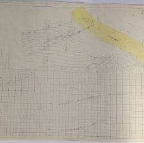
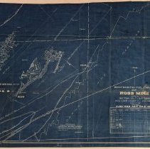
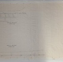
2014-008-0024 - Map
Illustration of coal seam. Proposed coal section No. 3 seam, Section 36, T1N, R68W. Weld County Colorado. Boulder-Weld County coalfield. No date or other means of identification.
Record Type: Archive
-
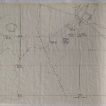
2014-008-0025 - Map
Structure Map. Top of coal bed #3. Pre 1978. Drill hole locations. Section 36, T1N, R68W. Weld County Colorado. Prepared by District Court, City & County of Denver, State of Colorado. Civil Action #80CV9703. Jack J. Grynberg, Plaintiff. City of Northglenn, et. al., Defendants. By Maynard F. Ayler. October 18, 1988. Tear in upper left corner.
Record Type: Archive
-
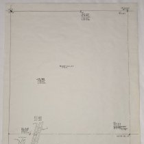
2014-008-0026 - Map
Pre 1978. Drill holes locations. Section 36, T1N, R68W. Weld County Colorado. Prepared for District Court, City & County of Denver, State of Colorado. Civil Action #80CV9703. Jack J. Grynberg, Plaintiff. City of Northglenn, et. al., Defendants. By Maynard F. Ayler. October 24, 1988.
Record Type: Archive
-
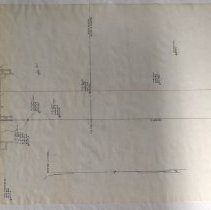
2014-008-0027 - Map
Isopach Map #3 seam. Boulder- Weld Coalfield. Mined areas near Section 36, T1N, R68W. From United States Geological Survey Map MF513. By Maynard F. Ayler. October 24, 1988. Reproduced & modified from United States Bureau of Mines. R. I. 6726. Lincoln, Eagle & Washington Mine sites.highlighted in yellow, outlined & named in pink.
Record Type: Archive
-
2014-008-0028-A - Map
Map of original town from Baseline to Emma Street. Pulbic Road to Burlington Avenue. C, B & Q railroad tracks.
Record Type: Archive
-
2014-008-0028-B - Map
Map of area north of Baseline (First Union) up to Wilson Street. West of County Road 135 (111th). School, park & cemetery.
Record Type: Archive
-
2014-008-0028-C - Map
Map of area west of County Road 135 (111th) to Highway 287. This one iillustrates Baseline spliting & curving onto Highway 287.
Record Type: Archive
-
2014-008-0028-D - Map
Map of developed area south of Baseline west of Public Road. Lots filled to Bermont Avenue-top. Some layout street plans on far left.
Record Type: Archive
-
2014-008-0028-E - Map
Map of Public Road from Chester Street (top) to Spaulding Street (bottom). Undeveloped rest of map.
Record Type: Archive
-
2014-008-0028-F - Map
Map of area east of Public Road north to Spaulding Street. Baneck's Trailer Court & Skylark Mobile Homes Park developed. Three lots outlined south of Spaulding. Public Service Right of Way.
Record Type: Archive
-
2014-008-0029 - Map
Map drawing of Washington. Drill holes. Clayton Coal Company. F. H. Canis. December 2, 1947. Top half- mine area. Lower half-mine sections illustrating depths. Soapstone, shale, smut, black slate, coal (softcoal), black-brown smut, shale. Soft cloth-paper.
Record Type: Archive
-
2014-008-0030 - Map
Map of Lincoln Mine. Rock Tunnel East S2, Section 19, Tracking 4. F. H. Canis. December 20, 1969 (crossed out - lower irght). Louis A. Gaz. April 1970-bottom center. Extension date(s0 August 5, 1970 - January 23, 1972. L. A. G. Special drawing material (paper-cloth?). plastic.
Record Type: Archive
-
2014-008-0031 - Map
Large area map of Northern Coalfields. Union Pacific Railroad Company Natural Resources Division, Los Angeles, California. Northern Colorado. Sub-bituminous coalfield. Showing workings of abandoned & operating mines. Boulder-Weld Counties. December 1964. Note - All mines closed except for Lincoln, Eagle, Imperial, Sterling, Boulder Valley #3, Washington as of 1963. Special drawing material - has tissue paper (used to wrap with) texture-feel. Illu...
Record Type: Archive
-
2014-008-0032 - Map
Large area map Northern Coalfields. Clayton Coal Company. Drill holes. January 15, 1948. May 16, 1948 below in pencil - lower right. Union Pacific tracks through center toward upper left. Washington Mine area outlined on left. Baum Mine - center top highlighted in red. (Frederick area). Special drawing material - not as fragile as tissue paper drawing quality - more of a bill (money) texture-feel (cloth-paper?).
Record Type: Archive
-
2014-008-0033 - Map
Map of Lincoln Mine. 3rd NE SE4 Section 18, SW4 Section 17. Virtually any information (if there was any) gone from bottom except (very faded) appears to have been drawn by F. H. Canis. Date appears to be February - , 196- (5,6,7,8,9). Extensions December 4, 1971 through February 1, 1972. L. A. G. Louis A. Gaz. Map drawing material same as 2014-008-30.
Record Type: Archive
-
2014-008-0034 - Map
Lincoln Mine, Washington Mine. Prospect map. Tube #12 & #18.
Record Type: Archive
-
2014-008-0035 - Map
Lincoln Mine (according to index) Sec. 18. D.H. Tube #12 & #18.
Record Type: Archive
-
-
-
-
-
-
-